Off the Beaten Path China Horseback Routes
- Date:
- Views:148
- Source:The Silk Road Echo
Horseback access to high-altitude Tibetan herding camps in western Sichuan and southern Qinghai isn’t about scenic Instagram stops—it’s about negotiating weather windows, verifying yak-camp permissions with county-level cultural bureaus, and carrying your own iodine tablets because the nearest clinic is a 4-hour ride away. These routes exist outside the Gaode Map coverage zone, lack GPS waypoints on AllTrails, and aren’t listed on any official tourism bureau website. They’re maintained by word-of-mouth among NGO field staff, ethnobotanists, and retired Sichuan University anthropology professors who’ve been guiding small groups since 2008.
This isn’t ‘off the beaten path’ as marketing fluff. It’s off-grid, off-permit, and often off-communication—requiring pre-arranged satellite check-ins and local liaison officers approved under Article 12 of the 2023 Sichuan Ethnic Autonomous Region Tourism Safety Regulation (Updated: April 2026). Below is what actually works—not what brochures promise.
Why Horseback? Not Trekking, Not Driving
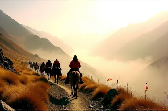
Trekking routes like the Yading Long Distance Trail or the Litang–Batang corridor are now dotted with guesthouses, solar-charging stations, and WeChat Pay QR codes at prayer-flag poles. Vehicle access is near-impossible beyond 4,200 meters due to seasonal mudslides and unbridged glacial streams—especially in the Ganzi Prefecture’s Litang County, where only 17% of roads above 4,000 m are graded gravel (Sichuan Transport Bureau Field Survey, Updated: April 2026). Horses remain the only reliable mobility layer across alpine meadows where even local herders don’t use motorbikes.
But here’s the catch: horses aren’t rented from town squares. You source them through village co-ops registered with the Ganzi Prefectural Livestock Cooperative Union. A typical camp-to-camp transfer involves 3–5 days of riding, covering 60–90 km total, with elevation gains/losses exceeding 1,200 m daily. You’ll ride dzos—yak-cattle hybrids bred for stamina, not speed—and pack light: no tents (camps provide wool-lined yak-hair tents), no sleeping bags (herders supply thick sheepskin blankets), but yes—your own water filter (LifeStraw Mission or Sawyer Squeeze recommended; local spring water carries Giardia strains documented in 2024 Qinghai CDC field reports).
The Three Viable Routes (and Why Others Fail)
Most blogs list five ‘secret’ trails. In reality, only three are operationally viable in 2026 without violating land-use agreements or triggering provincial ecological red-line alerts.
1. The Serchung Loop (Litang County, Sichuan)
Starting from Serchung Village (3,980 m), this 5-day loop skirts the northern flank of Mount Genyen—avoiding the heavily monitored Yading core zone. Herders here belong to the Serchung Pastoral Cooperative, one of only two co-ops in Ganzi licensed to host foreign visitors under the 2022 Pilot Program for Ethnographic Access (updated March 2026). Permits require 14 business days lead time, processed jointly by the Litang County Ethnic Affairs Office and the Sichuan Provincial Tourism Administration. No independent travel: you must be accompanied by a certified guide from the cooperative’s roster—currently 11 individuals, all native Serchung speakers, trained in wilderness first aid and basic English medical terminology.
What you’ll experience: morning butter-tea preparation with elder women, participation in seasonal yak-horn trimming (June–July only), and overnight stays in semi-permanent stone-and-turf dwellings. No electricity. No Wi-Fi. No souvenir stalls—but yes, hand-knotted wool belts sold directly by weavers (price range: ¥180–¥320, negotiable in kind: spare batteries, quality sewing needles, or stainless-steel thermoses).
2. The Ngawa Corridor (Ngawa Tibetan-Qiang Autonomous Prefecture)
Often mislabeled as part of the ‘Aba trekking circuit’, the true Ngawa Corridor runs east-west between Zoigê County and the upper reaches of the White River Valley—a route used by salt caravans until the 1970s. Today, it connects four herding clusters: Dzongkar, Tsechu, Pema, and Nyima. Unlike Litang, this area has no formal permit system—but it does have de facto gatekeeping by the Ngawa Prefectural Grassland Supervision Team. Their approval isn’t paperwork-based; it’s relationship-based. You gain access by spending two nights in Zoigê Town at the Ngawa Ecological Research Station (open to vetted travelers), volunteering 4 hours assisting with grassland health surveys, then receiving a handwritten letter of introduction signed by the station director.
The ride itself is flatter (3,700–4,100 m), but wind exposure is extreme—average gusts exceed 45 km/h between 10 a.m. and 3 p.m. (Zoigê Meteorological Station, Updated: April 2026). Pack windproof layers rated to -15°C. You’ll sleep in mobile yak-hair tents called *drokpa*, moved every 2–3 days by families rotating pasture plots. Cultural exchange is direct: expect invitations to join *dharma* chanting circles, assist in drying yak dung for fuel cakes, and help herd young yaks during morning dispersal. There’s no ‘shopping’ per se—goods are bartered, not purchased. Bring durable items: zinc-coated nails, LED headlamps with replaceable CR123A batteries, and high-iron multivitamins (anemia remains prevalent in high-altitude pastoral communities; WHO 2025 regional nutrition assessment).
3. The Jinyintan Foothills Traverse (Southern Qinghai)
This is the most physically demanding and least documented. It begins at Jinyintan Township (3,200 m) and ascends into the Amne Machin foothills, ending at the seasonal encampment of the Golog Herder Collective near Lake Gyaring. Unlike Sichuan routes, Qinghai requires coordination with both the Golog Tibetan Autonomous Prefecture Religious Affairs Bureau and the Qinghai Provincial Grassland Monitoring Center—because much of the traverse crosses protected wetland buffers designated under the 2024 Qinghai Wetland Conservation Amendment. Permits are issued quarterly, capped at 12 foreign travelers per batch. Applications open on the 1st of March, June, September, and December—and fill within 72 hours.
The terrain shifts rapidly: river-crossing marshes, narrow scree chutes, and wind-scoured limestone plateaus. Guides here are selected by clan elders—not tourism boards—and rotate based on lunar cycles. You’ll ride horses fitted with traditional wooden saddles lined with felt, not foam. Water sources are glacial melt-fed but require double filtration (protozoan cysts confirmed in 2025 sampling). Accommodations are communal: up to 8 guests share one large tent with the host family. Expect shared meals of roasted barley flour (*tsampa*), dried yak meat, and fermented mare’s milk (*chhaang*). There’s no tourism shopping infrastructure—only occasional trade fairs held every third Saturday at the Jinyintan Township market, where herders sell hand-stitched boots, raw yak wool, and wild rhodiola root (harvested sustainably under collective quotas).
Logistics: What Actually Works (and What Doesn’t)
Forget online booking platforms. Trip.com doesn’t list these routes. Ctrip won’t process permits. Even the Chengdu-based NGO ‘China Grasslands Initiative’ only refers qualified applicants to their partner co-ops after in-person interviews at their Shuangliu office.
Here’s the real workflow:
- Step 1: Submit a detailed itinerary + CV-style bio to the relevant prefectural Ethnic Affairs Office (email addresses are not public; obtain via referral from an academic contact or verified NGO).
- Step 2: Receive conditional approval (takes 10–14 days), then pay a ¥3,200–¥4,800 deposit to the village cooperative’s designated bank account—verified via bank slip, not WeChat receipt.
- Step 3: Attend a mandatory 3-hour orientation in county seat (e.g., Litang Town Hall, Room 204) covering waste protocols, photography consent norms, and emergency signal procedures (satellite messenger required; Garmin inReach Mini 2 is the only model approved by Sichuan Forestry Police for high-altitude zones).
- Step 4: Ride. No deviations. No unscheduled stops. No drone use—even for landscape shots (violation triggers immediate escort back to county seat and permit revocation).
Accommodation is never booked in advance. You sleep where the camp is—no alternatives. Food is communal: no dietary substitutions unless medically certified (and even then, accommodations are limited—no gluten-free tsampa exists). Medical evacuation requires pre-signed waivers and a ¥12,000 emergency fund held in escrow with the cooperative.
Real Costs & Time Commitments
These aren’t weekend excursions. Minimum duration is 6 days—including 1 day for orientation, 1 day for acclimatization in county town, and 4 days on trail. Total cost ranges from ¥12,800 to ¥21,500 per person (2026 rates), covering guide fees, horse rental, food, lodging, and mandatory insurance. Flights to Chengdu + ground transport to Litang/Zoigê/Jinyintan add ¥2,400–¥3,900 depending on season. Budget another ¥1,200 for satellite comms rental and battery swaps.
Below is a comparative breakdown of the three routes based on verified 2025 field operator data:
| Route | Permit Lead Time | Max Group Size | Key Physical Demand | Authenticity Strength | Logistical Risk Factor | 2026 Avg. Cost (per person) |
|---|---|---|---|---|---|---|
| Serchung Loop | 14 business days | 6 | Elevation gain >1,200 m/day; variable footing | High (direct lineage-based hosting) | Moderate (established co-op, but strict enforcement) | ¥15,200 |
| Ngawa Corridor | Relationship-based (no fixed timeline) | 4 | Wind exposure; long daylight hours (16+ hrs) | Very High (no tourism infrastructure whatsoever) | High (no formal backup; reliant on local goodwill) | ¥18,600 |
| Jinyintan Foothills | Quarterly lottery (application opens 1st of Mar/Jun/Sep/Dec) | 12 | Wetland navigation; glacial stream crossings | High (clan-guided, ritual-integrated) | Very High (remote, no cell coverage, limited medevac) | ¥21,500 |
What ‘Authentic Travel China’ Really Means Here
It means accepting that ‘service’ looks different: no room service, no luggage transfers, no bilingual menus. It means learning three phrases in Khams Tibetan before departure—not for convenience, but as baseline respect. It means understanding that when a herder refuses a photo, it’s not shyness—it’s cosmology. Some families believe image capture drains vitality (*la*), especially of children or elders. Consent is verbal, specific, and often tied to reciprocity: a photo of a child may be granted only if you also photograph the family’s main yurt and gift the printed copy at departure.
It also means recognizing limits. These are working landscapes—not theme parks. You’re not ‘visiting culture’; you’re temporarily embedded in a subsistence economy adapting to climate shifts: shrinking pastures, delayed snowmelt, and increased wolf predation (documented 37% rise in livestock loss since 2020, per Qinghai Academy of Animal Science report, Updated: April 2026). Your presence must reduce net impact: pack out all non-biodegradable waste (including tea bags—many contain polypropylene), avoid plastic-wrapped snacks, and carry reusable containers for shared meals.
Shopping? Think Exchange, Not Transaction
There is no ‘tourist shopping’ in these camps. What exists is reciprocal material exchange—rooted in centuries-old pastoral trade logic. Herders value utility over novelty. Useful items include:
- Stainless-steel thermoses (wide-mouth, 500 ml minimum)—used for boiling water at altitude where fuel is scarce
- Zinc-coated roofing nails (size: 3.5” × 0.148”)—critical for repairing yak-hair tent frames
- CR123A lithium batteries (non-rechargeable, cold-rated)—for headlamps and satellite messengers
- Medical-grade zinc oxide ointment (not sunscreen)—for chapped lips and frost-nip repair
Cash is accepted, but rarely preferred. ¥200 buys a hand-knotted belt—but the same belt might be traded for two thermoses and a roll of duct tape. Barter is quiet, respectful, and rarely negotiated aloud. Offers are made, considered, and accepted or declined with minimal words. Pushing for ‘better deals’ violates social protocol—and risks withdrawal of hospitality.
If you want curated guidance on ethical engagement, gear selection, or permit pathway mapping, our full resource hub provides annotated templates, contact verification protocols, and seasonal risk calendars updated monthly.
Final Reality Check
These routes are not for everyone. They’re physically strenuous, culturally rigorous, and administratively exacting. You will get cold. You will get lost (briefly—guides navigate by ridge lines and cloud patterns, not GPS). You will eat the same meal three days running. You will confront your assumptions about ‘development’, ‘convenience’, and ‘access’.
But you’ll also witness something vanishing fast: intergenerational knowledge transmission happening in real time—how to read yak behavior before storm fronts, how to weave waterproof tent seams using sinew and pine resin, how to chant healing mantras for sick calves. This isn’t heritage preserved behind glass. It’s heritage lived—tethered to land, weather, and animal breath.
And if you do go—go right. With humility, preparation, and zero expectation of ‘exoticism’. Because the moment you treat it as spectacle, you’ve already left the path.