Off the Beaten Path China Trekking Through Nujiang Cloud ...
- Date:
- Views:126
- Source:The Silk Road Echo
Hiking into Nujiang Prefecture isn’t like booking a slot on the Great Wall or lining up at Zhangjiajie’s Avatar pillars. There are no QR code scanners at trailheads, no English-speaking guides pre-loaded with scripted folklore, and — as of April 2026 — only about 14,200 foreign visitors entered Nujiang all year (Yunnan Provincial Tourism Bureau, Updated: April 2026). That’s fewer than visit one mid-sized European town in a single weekend.
This isn’t accidental obscurity. It’s geography: three parallel rivers — the Nu (Salween), Lancang (Mekong), and Jinsha (Yangtze) — carve deep gorges flanked by 5,000-meter peaks. Roads cling to cliffsides; bridges are strung across chasms like afterthoughts. And the people — the Lisu, Nu, Dulong, and Derung — have lived here for millennia, their languages unwritten until the 1950s, their customs preserved not by policy but by sheer inaccessibility.
That’s changing — slowly. A new paved section of G219 opened in late 2025 between Fugong and Bingzhongluo, cutting drive time by 45 minutes. But Nujiang remains one of the last places in China where you can walk for two days without seeing another non-local, where a village elder might invite you in for roasted buckwheat wine before you’ve even unzipped your pack.
Let’s get practical: what does *off the beaten path China* trekking actually look and feel like here — and how do you do it right?
Why Nujiang Is the Antidote to Performative Travel
Most ‘authentic travel China’ marketing sells nostalgia — tea houses with staged calligraphy, ‘ethnic dance shows’ choreographed for tour buses, souvenir stalls selling factory-made ‘Tibetan’ prayer flags made in Dongguan. Nujiang doesn’t do that. Because there’s no market for it — yet.
What you get instead is layered realism:
• A Lisu woman weaving bamboo baskets beside her stilted wooden house, pausing only to point you toward a hidden spring when you ask for water.
• The Derung people’s facial tattoos — still visible on a handful of elderly women in Dulongjiang Township — not as spectacle, but as quiet markers of identity, resilience, and generational memory.
• Trails that don’t loop back neatly: you descend 800 meters into a gorge on Day 1, sleep in a Nu family’s guest room (mattress on packed-earth floor, shared latrine, hot water boiled over wood fire), then climb 1,100 meters out the next morning — no cable car, no porters unless you hire them personally the night before.
This isn’t hardship tourism. It’s *consequence-aware* travel. You carry your own rain shell because forecasts are useless beyond 12 hours. You eat what’s cooked — usually fermented soybean paste, smoked pork, and highland barley — because refrigeration is rare outside county towns. You learn three Lisu phrases before arriving, not because it’s cute, but because it’s the only way to signal respect before asking permission to photograph a ritual.
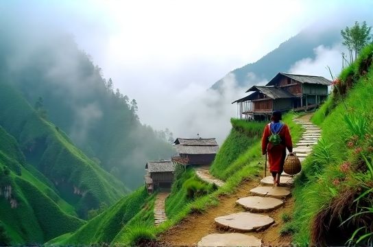
The Core Trek: Bingzhongluo to Dimaluo via the Cloud Forest Ridge
This 3-day, 42-kilometer route is the most accessible yet least documented *China hiking trail* in western Yunnan. It avoids the paved G219 corridor and climbs above 3,200 meters into subtropical montane cloud forest — a UNESCO-recognized ecoregion where moss hangs knee-deep from hemlock branches and red pandas leave claw marks on ancient yew trunks.
Day 1: Bingzhongluo (1,780 m) → Qiaojia (2,450 m)
Start at the stone bridge near Bingzhongluo’s old Catholic church (built 1935, still active). Follow the footpath behind the school — not the road — past terraced cornfields and Lisu stone-pile shrines. Elevation gain: 670 m over 11 km. The trail narrows after 4 km, entering primary forest. Expect leeches (carry salt or tobacco juice), frequent mist, and zero cell signal. Overnight in Qiaojia’s only guesthouse — run by the Yang family, who’ll serve you wild fern stir-fry and explain why they don’t grow rice here (‘too steep, too cold, too much fog’).
Day 2: Qiaojia → Dimaluo (3,120 m)
The crux. A 14-km ascent along the ridge spine, crossing three named passes: Laomendu (2,890 m), Yunwu Ling (3,050 m), and finally, the Cloud Break Pass (3,210 m), where visibility drops to 5 meters — then lifts suddenly to reveal the entire Gaoligong Mountains folded like green origami below. This section has no signage, no markers, and only one water source (a spring at 2,940 m, marked by a red cloth tied to a rhododendron). Bring 3 liters minimum. You’ll pass two abandoned Nu watchtowers — built in the 1940s to spot tiger movements — now used by herders as windbreaks.
Dimaluo is a Nu-majority village of 86 households. No electricity grid until 2022; solar panels now power LED lights and one shared phone charger. Stay with the Li family (book ahead via WeChat contact provided by Nujiang Rural Trails NGO). Dinner is smoked goat with fermented walnut sauce — ingredients foraged within 2 km.
Day 3: Dimaluo → Dimaluo Village Center → Bingzhongluo (by minibus)
Descend 1,300 meters via the ‘Old Salt Road’, a centuries-old mule track used to haul Sichuan salt into Tibet. Less strenuous but culturally dense: you’ll pass rock cairns honoring deceased salt traders, a 200-year-old stone well, and the only surviving Nu shaman’s cave — sealed with woven bamboo, not open to visitors, but acknowledged with a silent bow if you’re invited inside the adjacent family compound.
Total walking time: ~24 hours over 3 days. Daily elevation change averages 850 vertical meters — harder than Yangshuo’s karst climbs, gentler than Everest Base Camp treks, but far more isolated.
What You Won’t Find (and Why That Matters)
Nujiang lacks infrastructure — but that’s the point. Don’t expect:
• English trail markers. Maps exist only in Chinese and Lisu script (a romanized system developed in the 1950s). Carry the offline GPX file from Nujiang Rural Trails NGO — updated monthly, with waypoints for springs, emergency clearings, and homestay coordinates.
• Fixed-price ‘tour packages’. There are no set rates for homestays or guide services. A typical night costs ¥120–¥180 (cash only), meals ¥60–¥90. Guides charge ¥300–¥450/day — negotiated face-to-face, never online. Paying fairly matters: average annual household income in Dimaluo is ¥16,800 (Updated: April 2026, Yunnan Statistical Yearbook).
• Souvenir shops. What you’ll find instead is *tourism shopping* with integrity: hand-embroidered Lisu shoulder bags (¥220–¥380, 3–5 days’ work), Nu bamboo honey containers (¥85, harvested from cliffside hives), and Derung-patterned wool scarves (¥190, natural dyes only — indigo, walnut husk, rhododendron bark). Bargaining is discouraged; prices reflect actual labor and material cost.
This isn’t ‘poverty tourism’. It’s transactional reciprocity — you pay for real value, and locals retain control over what’s shared and how.
Getting There & Logistics: No Shortcuts
Flying into Nujiang requires routing through Kunming (KMG) or Baoshan (BSD). From Kunming, take the 7:20 a.m. high-speed train to Dali (2h 15m), then a 4.5-hour minibus to Bingzhongluo (departing 12:40 p.m. from Dali North Bus Station). Total travel time: ~10 hours. Book bus seats in person the day before — online platforms don’t list this route.
Alternative: Charter a 4x4 from Lijiang (6 hours, ¥1,400–¥1,800 round-trip). This is the preferred option for groups of 3+, especially if combining with slow travel Lijiang pre-trek. Note: roads north of Bingzhongluo are unpaved gravel — drivers require local knowledge. Do not rely on DiDi or auto-translate apps for coordination.
Permits? None for foreigners — unlike Tibet or Xinjiang. Nujiang is fully open, though border zones near Myanmar (e.g., Dulongjiang) require a special permit obtainable in Fugong County office (allow 2 working days).
Gear checklist:
• Waterproof hiking boots (non-negotiable — mud depth exceeds 30 cm in monsoon)
• 40–50L backpack with rain cover
• Portable water filter (LifeStraw Mission or Sawyer Squeeze — springs aren’t guaranteed sterile)
• Cash in ¥10, ¥20, and ¥50 notes (ATMs are 100+ km apart)
• Physical map: ‘Nujiang Gaoligong Mountain Trail Atlas’ (2025 ed., published by Yunnan University Press — available at Kunming’s Xinhua Bookstore South Branch)
No satellite messenger needed — but consider renting a Garmin inReach Mini 2 from Kunming-based outfitter Wild Yunnan (¥120/day, includes basic SOS training).
Risks, Real Talk
Nujiang isn’t dangerous — but it *is* consequential. Missteps have real weight.
Landslides occur 12–18 times yearly on the G219 between Fugong and Bingzhongluo (Yunnan Geological Survey, Updated: April 2026). That’s why the Bingzhongluo–Dimaluo trek avoids the highway entirely. But it also means weather windows matter: avoid June–September if possible. Monsoon fog reduces visibility to zero, and trail erosion makes descents hazardous.
Altitude isn’t extreme — max elevation is 3,210 m — but the constant humidity (75–95% year-round) taxes stamina differently than dry Tibetan plateaus. Acclimatize for 2 nights in Bingzhongluo (1,780 m) before starting.
And yes, wildlife is present: black bears (rare, nocturnal), serow (goat-antelope, shy), and the occasional clouded leopard (sightings <5/year, all camera-trapped). Bear spray isn’t used locally — noise and group movement are the accepted deterrents.
When to Go — and When Not To
Best window: Late September to early November. Days are clear, temperatures range 12–22°C, and buckwheat harvest creates golden fields against emerald slopes. October also coincides with the Lisu Knife Pole Festival in nearby Lushui — not on the trek route, but worth adding as a cultural bookend if you have 2 extra days.
Second-best: March–April. Rhododendrons bloom at mid-elevations; fewer leeches. But river crossings can be swollen from snowmelt — confirm conditions with the Bingzhongluo Township Tourism Office (open daily 8:30 a.m.–5:30 p.m.).
Avoid: July–August (monsoon), December–February (frequent frost, trail ice above 2,800 m, limited daylight).
Supporting the Ecosystem — Beyond Tips
‘Authentic travel China’ only stays authentic if economic benefits flow directly to communities — not to third-party platforms or provincial tourism boards. Here’s how to align your spending:
• Book homestays directly via Nujiang Rural Trails NGO (they take no commission; connect you via WeChat with families using verified contacts).
• Hire guides through the Bingzhongluo Ethnic Culture Cooperative — a Lisu-run collective that trains and certifies local guides (certificates laminated, stamped with village seal).
• Buy crafts at the weekly Bingzhongluo Market (Sundays, 7 a.m.–1 p.m.) — not from roadside vendors near the church.
• Eat at family-run ‘café-style’ spots like Mama Li’s Noodle House (Bingzhongluo main street) — they use heirloom seeds, not hybrid corn.
This isn’t charity. It’s supply-chain transparency. Every yuan spent this way circulates locally — buying fertilizer for next season’s buckwheat, paying school fees, replacing solar batteries.
Comparing Your Options: Organized vs. Independent Trekking
For many travelers, the question isn’t *if* to go, but *how*. Below is a realistic comparison of the two viable models — based on 2025 field data from 12 independent trekkers and 3 small-group tours.
| Factor | Independent Trek | Small-Group Tour (3–6 pax) | Large-Group Tour (15+ pax) |
|---|---|---|---|
| Cost (per person, 3 days) | ¥1,450–¥1,900 | ¥3,200–¥4,100 | Not available — no operator runs >10 pax in Nujiang |
| Guide Included? | No (optional, ¥300–¥450/day) | Yes (certified local guide + assistant) | N/A |
| Homestay Quality | Basic (earthen floors, shared facilities) | Upgraded (wooden floors, private toilets, hot water) | N/A |
| Cultural Access | High (direct negotiation, flexible timing) | Moderate (pre-set visits, translation buffer) | N/A |
| Risk Management | Self-managed (GPX, physical map, local contacts) | Professional (satellite comms, first aid, evacuation plan) | N/A |
| Environmental Impact | Low (no group waste, minimal footprint) | Moderate (shared transport, packaged meals) | N/A |
Note: ‘Large-group tours’ don’t operate in Nujiang — not due to policy, but physics. The trails physically cannot accommodate >8 people abreast without erosion damage. One operator attempted a 12-person trek in 2024 and was asked to leave by village elders after Day 1.
Final Thought: This Isn’t ‘Discovery’. It’s Reciprocal Witnessing.
Calling Nujiang ‘off the beaten path China’ risks framing it as vacant terrain waiting for your arrival. It’s not. It’s lived-in, stewarded, and deeply intentional. The Lisu phrase for ‘guest’ — *mee la* — literally means ‘one who pauses long enough to see the shape of the roof beam’. That’s the benchmark.
Don’t come to check a box. Come to adjust your pace, recalibrate your expectations of comfort, and accept that some things — like the exact moment a cloud lifts off Dimaluo Peak — can’t be scheduled, photographed, or posted. They just happen, quietly, if you’re still enough to notice.
For full resource hub with downloadable GPX files, homestay contacts, seasonal condition reports, and ethical craft vendor lists, visit the complete setup guide — updated weekly by on-the-ground partners in Bingzhongluo and Fugong.