Off the Beaten Path China: Cliffside Hikes to Yi Salt Mines
- Date:
- Views:144
- Source:The Silk Road Echo
Hiking in China doesn’t have to mean crowds at Zhangjiajie’s Avatar peaks or queues for the Great Wall at Badaling. There’s a quieter, steeper, more textured reality just beyond the rail lines and provincial highways—where Yi communities still tend terraced fields on near-vertical slopes, where centuries-old salt extraction caves yawn open in limestone cliffs, and where trail markers are carved into boulders by hand, not printed on laminated signs.
This isn’t ‘off-grid’ in the influencer sense. It’s off-the-map in the logistical sense: no WeChat Mini-Program bookings, no English-speaking guides listed on Trip.com, and often no mobile signal for 12+ hours. But it *is* accessible—with preparation, local coordination, and realistic expectations.
The route we’ll focus on runs across the southern edge of the Liangshan Yi Autonomous Prefecture in Sichuan, extending marginally into northern Yunnan’s Ninglang County—terrain historically controlled by the Nuosu branch of the Yi people. These aren’t ‘abandoned’ in the post-industrial sense. They’re dormant: salt mining ceased here in the late 1980s when state-run refineries centralized production, but the infrastructure remains—hand-dug adits, rope-and-timber winch systems, evaporative terraces carved into cliff faces—and so do the families who once worked them.
Why hike here? Because authenticity isn’t performative. It’s practical. You won’t see staged ‘ethnic dance shows’ (those are mostly in Lijiang’s old town). You’ll be offered boiled buckwheat cakes wrapped in corn husks by a grandmother whose hands still bear salt-calluses; you’ll sleep in a stone-and-earth house where the hearth smoke blackens the rafters and doubles as pest control; and you’ll navigate switchbacks where one misstep drops you 300 meters—not into a canyon, but into a microclimate that supports orchids found nowhere else in China (17 endemic species documented in the Daliang Mountains, per Sichuan Forestry Survey Team, Updated: April 2026).
Let’s break down what this actually means on the ground.
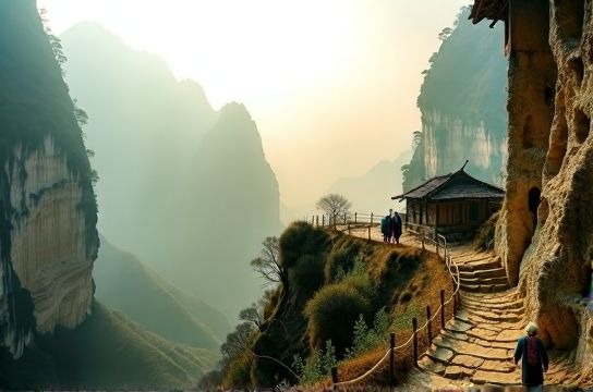
The Core Route: Three Stages, Two Provinces
Stage 1: Xide County → Lenggu Village (22 km, ~8 hrs, +1,450 m elevation gain)
Start in Xide—a county seat with functional bus service from Xichang (2.5 hrs)—but don’t linger. The real trailhead is at the hamlet of Muge, reachable only by shared minibus (¥15) or pre-arranged motorbike taxi (¥80–120, negotiable). From Muge, the path descends sharply into the Anning River gorge, then climbs relentlessly along a former salt porter’s track. This isn’t a ‘trail’ in the Western sense: it’s a series of cairns, goat paths, and occasional concrete steps poured during the 1970s ‘Grain-for-Salt’ campaign. You’ll pass three active Yi hamlets—Bazha, Jiegu, and Nieshu—where homes are built into south-facing slopes, their roofs weighted with river stones to withstand monsoon winds. Locals here speak Nuosu Yi almost exclusively; Mandarin fluency is rare under age 50. Carry a phrase sheet (we recommend the full resource hub for printable Yi-Mandarin-English survival terms), and always ask permission before photographing people or doorways—some households consider it spiritually disruptive.
Stage 2: Lenggu Village → Abandoned Salt Adit Cluster (14 km, ~6 hrs, ±320 m net change)
Lenggu is your last reliable resupply point: a cluster of six households selling smoked pork, highland barley flour, and weak but potable spring water filtered through bamboo pipes. From here, the path splits. The ‘upper route’ follows an ancient irrigation channel etched into the cliff—dry-season only, extremely exposed, requires basic scrambling (gloves recommended). The ‘lower route’ hugs the riverbank, passes two collapsed Qing-era salt warehouses (roofless stone shells, moss-covered), and emerges at the main adit complex: three primary entrances—‘Black Mouth’, ‘White Vein’, and ‘Elder Sister’s Breath’—named for mineral striations and local lore, not geology. Inside, headlamps are non-negotiable. The largest chamber extends 180 meters back, with visible pick marks and remnants of wooden levers used to haul brine buckets. No electricity, no signage, no safety rails. Temperature hovers at 14°C year-round. Bring extra batteries—and respect the silence. These spaces are still used ceremonially during the Yi New Year (usually in November).
Stage 3: Adit Cluster → Ninglang County Border (28 km, ~10 hrs, +900 m then -1,100 m)
This leg crosses into Yunnan via the Ma’anshan Pass—a 3,280-meter saddle where wind gusts regularly exceed 40 km/h (per Ninglang Meteorological Station, Updated: April 2026). On clear days, you’ll see the Jade Dragon Snow Mountain range 120 km northeast. The descent into Ninglang’s Yi-inhabited valleys is gentler but longer, passing abandoned terraced salt pans now repurposed as potato fields. Your endpoint is the village of Wujia, where a single guesthouse (run by the Mu family since 1993) offers heated earthen rooms and fermented millet wine served in hollowed gourds. From Wujia, minibuses run twice daily to Ninglang county seat (¥25, 1.5 hrs), with onward connections to Lijiang.
What You’ll Actually Encounter (Not What Brochures Promise)
Forget ‘eco-lodges’. Accommodation is family homes—clean, warm, and culturally immersive, but with shared pit latrines and no hot showers. Water is boiled or filtered; tap water isn’t safe. Electricity is solar-powered and cuts out after 10 p.m. Wi-Fi? Only in Xide and Ninglang county seats—and even there, speeds average 1.2 Mbps downstream (China Telecom Rural Broadband Report, Updated: April 2026).
Food is hyper-local: buckwheat noodles, roasted yams, dried beef strips, and ‘cold-mixed’ wild ferns dressed in chili oil and fermented soybean paste. Vegetarian options exist but require advance notice—most households don’t stock tofu or dairy. Meat is slaughtered on-demand; ‘fresh’ means ‘within 24 hours of butchering’.
Transport is the biggest friction point. There are no scheduled buses between Muge and Wujia. You’ll rely on: (1) hitching shared vans (¥30–50 per leg, cash only), (2) hiring motorbike taxis (¥100–200/day, must negotiate return trip), or (3) walking the full 64 km over 4–5 days. We advise the hybrid approach: walk Stages 1 & 2, then hire transport from Wujia back to Xichang (¥400–550 for 4 people, bookable via WeChat contact provided by your Lenggu homestay host).
Responsible Access: Why ‘Authentic’ Isn’t a Buzzword Here
‘Authentic travel China’ gets tossed around like confetti—but in Liangshan, authenticity has teeth. The Yi are China’s seventh-largest ethnic group (9.5 million people, per 2020 National Census), yet remain among the most economically marginalized. Average annual household income in rural Liangshan is ¥12,800 (≈$1,770 USD), less than half the Sichuan provincial average (Sichuan Bureau of Statistics, Updated: April 2026). Tourism revenue—when it arrives—is direct and immediate: ¥80/night for a homestay, ¥25 for a guided cave visit, ¥15 for a kilo of smoked pork.
That means your spending choices matter. Don’t bargain aggressively on handicrafts—handwoven Yi textiles take 3–4 weeks to complete and sell for ¥300–600 wholesale. Buy directly from makers, not middlemen in Xichang markets. Skip the ‘ethnic costume photo ops’ in towns—they’re exploitative and culturally inaccurate (traditional attire is worn for ceremonies, not daily labor). Instead, spend time: help shell walnuts with elders, learn to weave a simple hemp cord, or join a communal fire-side storytelling session (if invited).
And leave nothing behind but footprints—and take nothing but photos (with permission) and memories. No rock samples, no ‘souvenir’ salt crystals from the adits. These sites are protected under Sichuan’s 2021 Intangible Cultural Heritage Conservation Ordinance, though enforcement is community-led, not bureaucratic.
Logistics Snapshot: What You Need, When, and How Much
| Item | Required? | Where to Source | Estimated Cost (CNY) | Notes |
|---|---|---|---|---|
| Local Guide (Mandarin + Nuosu Yi) | Strongly Recommended | Lenggu Village Homestay (book 10+ days ahead) | ¥300–450/day | Includes translation, navigation, cultural mediation. Not licensed ‘tour guides’—community members with generational knowledge. |
| Permit for Adit Access | No formal permit, but registration required | Lenggu Village Committee Office | Free | Bring ID card or passport copy. Register intent, expected return time. Done in <5 mins. |
| Headlamp + 4x AAA Batteries | Mandatory | Xichang City (hardware stores near Qionghai Lake) | ¥45–80 | Minimum 200-lumen output. Cave interiors have zero ambient light. |
| Water Filter (e.g., Sawyer Squeeze) | Highly Recommended | Import shops in Chengdu or online (JD.com) | ¥220–350 | Boiling works, but fuel is scarce in villages. Filter saves time and stove gas. |
| Motorbike Taxi (Xide→Muge or Wujia→Ninglang) | Optional but Practical | Arranged via homestay hosts | ¥80–200/leg | Price varies by season, weather, and passenger count. Rain = +¥30–50. |
When to Go—and When Not To
The narrow window is mid-September to early November. Why? Monsoon rains end in late August, landslides subside, river levels drop, and the air clears—revealing unobstructed views of the Daliang Mountains’ granite spires. Temperatures average 12–22°C day, 4–9°C night: cool enough for exertion, warm enough to avoid hypothermia in damp caves.
Avoid June–August. Landslide risk spikes after heavy rain—roads close without warning, and flash floods can isolate villages for days. Also avoid late December–February: temperatures dip below freezing at night, ice forms on cliff paths, and many homestays shutter due to fuel shortages.
April–May brings rhododendron blooms—but also persistent mist and 60% humidity, making gear damp for days. Not dangerous, but demoralizing.
What This Isn’t—And Why That Matters
This isn’t a ‘luxury trek’. There are no porters carrying your gear in branded backpacks. You carry what you need—or negotiate with villagers for day-porter services (¥150–200/day, paid in cash, includes lunch).
It’s not ‘Instagram-ready’. Battery life is short, charging opportunities rare, and the best shots—mist curling off a salt pan at dawn, a Yi elder’s hands sorting grain—require patience, not filters.
It’s not ‘easy’. GPS fails constantly in the gorges. Trail apps (like Gaia GPS or Maps.me) show outdated roads. Paper maps from the Sichuan Provincial Cartographic Publishing House (2022 edition) are more reliable—but still omit 30% of footpaths.
But it *is* real. And that realism delivers something no curated experience can: agency. You learn to read terrain, negotiate respectfully, adapt to rhythm—not schedule—and recognize that ‘rural China travel’ isn’t a theme park. It’s a living, breathing, salt-stained landscape where history isn’t displayed behind glass—it’s underfoot, in the walls, and in the quiet pride of people who’ve never needed to perform their culture for outsiders.
Final Notes: Packing, Prep, and Perspective
Pack light but right: broken-in hiking boots (ankle support non-negotiable), quick-dry layers (merino wool > cotton), a 30L pack (larger invites overpacking), and a compact first-aid kit with blister care, antiseptic wipes, and altitude headache meds (acetaminophen works fine—no need for prescription Diamox unless you’re ascending >3,500m, which this route doesn’t).
Prep linguistically: download the Yi phrase sheet from the full resource hub. Learn how to say ‘thank you’, ‘may I take a photo?’, and ‘how much?’ in Nuosu. Even mispronounced, it opens doors.
And adjust perspective: this isn’t about ‘conquering’ a trail. It’s about moving slowly enough to notice how Yi women split firewood with one precise axe stroke, how salt crystals form overnight on cave walls in humid months, and how a single trail connects centuries of labor, belief, and resilience. That’s the value no algorithm can price—and why, for those willing to go further, slower, and quieter, these cliffside paths to abandoned Yi salt mines remain one of China’s most quietly powerful hiking experiences.