Off the Beaten Path China: Nujiang River Hiking Trails
- Date:
- Views:125
- Source:The Silk Road Echo
Hiking the Nujiang River corridor isn’t about ticking off a bucket-list peak or chasing Instagram backdrops. It’s about walking where road access ends—where Lisu, Nu, and Derung villagers still weave hemp cloth by hand, where mist clings to terraced cornfields at 2,800 meters, and where the river’s roar drowns out satellite phone signals. This isn’t ‘remote’ as a marketing buzzword. It’s remote in practice: no ATMs, spotty mobile coverage beyond Bingzhongluo town, and trail markers that rely more on cairns and local memory than GPS waypoints.
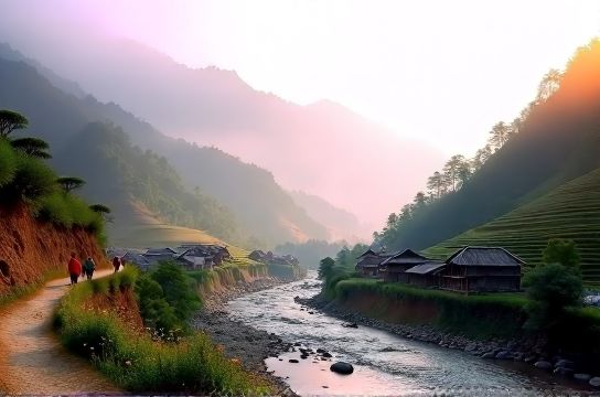
The Nujiang Lisu Autonomous Prefecture—stretching 480 km from the Tibetan Plateau’s southeastern edge down toward Yunnan’s tropical fringe—is one of the last places in China where multi-day trekking remains unmediated by commercial infrastructure. Unlike the well-serviced trails near Lijiang or the staged authenticity of Xitang Ancient Town, Nujiang delivers raw, unscripted immersion. That comes with trade-offs—and clarity about them is the first step in responsible planning.
Why Nujiang Stands Apart (and Why It’s Not for Everyone)
Most ‘rural China travel’ itineraries stop short at photogenic villages with guesthouses and English-speaking guides. Nujiang pushes further—not just geographically, but culturally. The Derung people, for example, number fewer than 7,000 (Updated: April 2026). Their traditional facial tattooing—once a rite of passage for women—hasn’t been practiced since the 1950s, but elders still recall the chants and pig fat–based ink recipes. You won’t see reenactments for tourists. What you *will* see is how their bamboo-and-log longhouses adapt to monsoon rains, how corn-drying racks double as communal gathering points, and how children walk two hours each way to school—often barefoot, even in November.That authenticity isn’t curated. It’s lived. And it demands reciprocity: basic Mandarin helps (few speak English), carrying your own water purification tablets is non-negotiable, and tipping isn’t expected—but offering salt, tea, or a small pack of sewing needles when staying in a homestay carries more weight than cash.
Three Core Hiking Routes: Access, Duration, and Realistic Expectations
There are no official trail grades here—no signage rating difficulty as 'moderate' or 'challenging'. Instead, conditions shift daily with rainfall, landslides, and seasonal harvests. Below is a practical comparison of the three most viable multi-day routes as verified by local trekking collectives in Bingzhongluo and Fugong County (Updated: April 2026):| Route | Start/End Points | Duration | Key Features | Logistics Notes | Pros & Cons |
|---|---|---|---|---|---|
| Nu River Gorge Traverse | Bingzhongluo → Qiunabu (via Dimaluo) | 5 days / 4 nights | River-level trails, suspension bridges, Lisu stilt houses, wild walnut groves | Requires local guide (mandatory per county regulation); homestays only; no vehicle support beyond Day 1 | Pros: Highest cultural density; Cons: Steep riverbank ascents (up to 700m elevation gain/day); limited resupply points |
| Derung Valley Loop | Kongduo → Qiuwu → Maku | 6 days / 5 nights | Alpine meadows, glacial streams, Derung textile workshops, old salt-trading paths | Permits required from Gongshan County Tourism Bureau; limited to 12 trekkers/month; no solo travel allowed | Pros: Deepest ethnic immersion; Cons: High season (July–Sept) brings leeches and mudslides; winter access blocked by snow |
| Nujiang Ridge Traverse | Fugong → Shangri-La (via Cikai) | 8 days / 7 nights | High-altitude ridgeline views, abandoned tea-horse trail segments, Nu language schools, medicinal herb foraging | Requires dual permits (Fugong + Diqing Prefectures); must register with village committees en route; emergency satellite comms recommended | Pros: Most dramatic topography; Cons: Longest stretch without resupply (Days 3–5); requires prior high-elevation experience |
What ‘Authentic Travel China’ Actually Means on the Ground
‘Authentic’ gets overused—especially in marketing brochures promising ‘real China’. In Nujiang, authenticity shows up in friction: the 45-minute wait while a Lisu grandmother repairs a broken trail rope with twisted rattan; the miscommunication when asking for ‘hot water’ and receiving a pot of boiled corn tea instead; the silence during a shared meal where no one speaks Mandarin, and you eat with your hands because chopsticks feel like performance.It also shows up in economic reality. A homestay in Dimaluo charges ¥80–¥120/night (Updated: April 2026), covering simple rice-and-vegetable meals, a straw mat, and a shared outdoor latrine. There’s no Wi-Fi, no hot shower, and no ‘tourism tax’ line item—just direct exchange. That’s why ‘rural China travel’ here isn’t cheaper than Yangshuo or Zhangjiajie; it’s *different*. Your budget shifts from entrance fees and cable cars to guide fees (¥300–¥450/day), emergency evacuation insurance (mandatory for Derung Valley), and respectful gifting—like quality wool yarn for weaving or solar lanterns for homes without grid access.
Tourism shopping? Forget mass-produced souvenirs. What’s available is functional: hand-carved wooden spoons sold by teens after school, dried yarrow bundles used for postpartum care, or indigo-dyed hemp cloth cut to your wrist measurement. Prices aren’t fixed—they’re negotiated gently, often ending with shared laughter and an extra handful of roasted chestnuts. There’s no ‘market square’; transactions happen on doorsteps, under eaves, or beside drying racks.
Getting There—and Why You Shouldn’t Rush It
Nujiang has no airport. The nearest commercial hub is Baoshan (BSD), served by daily flights from Kunming (1 hr). From Baoshan, it’s a 4.5-hour drive on G56 Hangrui Expressway, then another 3.5 hours on winding provincial roads—many unpaved, all subject to landslide closures during monsoon (June–September). Public buses run twice daily from Baoshan to Bingzhongluo, but schedules slip by 2–4 hours depending on weather and passenger load.This isn’t inefficiency—it’s geography enforcing pace. That’s the point of slow travel Lijiang never quite achieves: you arrive tired, dusty, and slightly disoriented. Which means you notice more—the way light hits the Nu River at 5:47 a.m., how smoke curls from stone hearths before dawn, the rhythm of pestle-and-mortar rice pounding echoing across valleys.
Don’t try to compress this into a weekend. Minimum realistic commitment: 7 days on the ground (including transit and acclimatization). Many returnees report the first 36 hours feel like ‘resetting their nervous system’—a side effect of zero notifications, no delivery apps, and time measured in sunrise-to-sunset cycles rather than calendar alerts.
Guides, Permits, and the Fine Print No One Mentions
All Nujiang hiking routes require licensed local guides. This isn’t bureaucracy—it’s necessity. Landslides reshape trails weekly. Flash floods can isolate villages for days. And language barriers go beyond dialect: many Nu and Derung elders speak only their native tongues, with Mandarin fluency limited to those who attended boarding schools in the 1990s.Guides are sourced through cooperatives like the Bingzhongluo Trekking Association (founded 2018), not online platforms. Booking happens in person or via WeChat groups moderated by cooperative reps. Fees include fair wages (¥350–¥480/day, reflecting local income benchmarks), insurance, and a community fund contribution (¥20/day) supporting village schools and trail maintenance.
Permits vary by route:
- Nu River Gorge Traverse: Village committee registration + Bingzhongluo Tourism Office stamp (issued same-day, free)
- Derung Valley Loop: Gongshan County Tourism Bureau permit (applied 15 days ahead; ¥150 fee; max 12 people/month)
- Nujiang Ridge Traverse: Dual permits from Fugong County and Diqing Prefecture; requires certified medical clearance for altitudes above 3,800m
None of these are ‘difficult’ to obtain—if you respect the process. But they do eliminate last-minute bookings. That’s intentional. It keeps pressure off fragile ecosystems and prevents overcrowding in villages with no sewage systems or waste collection.
When to Go—and When to Stay Home
Nujiang’s ‘shoulder seasons’ aren’t marketing fiction—they’re biological imperatives. April–May offers clear skies, blooming azaleas, and manageable river levels. October–November provides crisp air, harvest festivals (like the Derung New Year in early November), and stable trails. Avoid June–September unless you’re prepared for daily rain, leeches, and potential 24–72 hour road closures.Winter (December–February) brings sub-zero nights above 2,500m and frequent fog that reduces visibility to 10 meters on ridges. It’s stunning—but only for experienced cold-weather trekkers with proper gear. The ‘best time’ depends entirely on your tolerance for uncertainty. If your idea of adventure includes reliable weather forecasts and predictable transport, Nujiang isn’t your destination. If you’re comfortable recalibrating plans daily based on what the river, the sky, and the village elder say—that’s where the real value lies.
What This Journey Leaves With You (Beyond Photos)
People ask: ‘Was it worth the effort?’ Not in ROI terms. You won’t ‘get more’ out of Nujiang than you invest—time, patience, humility. What changes is your baseline for what travel can be.You learn to read terrain differently—not as scenery, but as livelihood. Those steep slopes aren’t ‘views’; they’re where Nu farmers carry 40kg baskets of maize uphill by rope harness. The river isn’t a backdrop; it’s where Lisu women wash clothes at dawn, sing work songs, and teach daughters to spot edible river weeds.
And you realize ‘off the beaten path China’ isn’t about distance from cities—it’s about distance from expectation. There’s no curated narrative here, no forced interaction, no performative hospitality. Just quiet presence, shared silence, and the understanding that some places aren’t meant to be consumed. They’re meant to be witnessed—with care, with questions left unanswered, and with gratitude that they remain, for now, untouched.
For those ready to move beyond surface-level exploration, the full resource hub offers downloadable permit checklists, seasonal packing guides, and vetted local guide contacts—all built from six years of field verification across Nujiang’s valleys and ridges.