Off the Beaten Path China: Nujiang Valley Hiking Trails
- Date:
- Views:132
- Source:The Silk Road Echo
Hiking in Nujiang Lisu Autonomous Prefecture isn’t about ticking off a trail name on an app. It’s about crossing rope bridges strung over roaring rapids at 1,800 meters, sharing roasted buckwheat cakes with Lisu elders who’ve never seen a foreign passport, and realizing your GPS signal vanished three hours ago — and you’re better for it. This is not Yunnan’s curated Lijiang or Xitang Ancient Town (which, despite its charm, hosts over 12 million annual visitors — Updated: April 2026). This is Nujiang: a 480-kilometer north-south rift carved by the Salween River, flanked by 5,000-meter peaks, home to fewer than 600,000 people across four major ethnic groups — Lisu, Nu, Dulong, and Bai — and visited by fewer than 35,000 international hikers per year (China National Tourism Administration, 2025 field survey; Updated: April 2026).
Nujiang doesn’t appear on most international trekking circuits because it lacks the infrastructure — and that’s precisely why it delivers what so many claim to seek: authentic travel China. Not staged performances, not souvenir stalls selling ‘ethnic’ keychains made in Guangdong, but daily life unfolding at its own rhythm: women weaving indigo-dyed hemp cloth by hand, men repairing wooden water wheels fed by mountain springs, children walking two hours each way to school along switchbacks where mule trains still outnumber motorcycles.
Let’s be clear: this isn’t a luxury trek. There are no heated yurts with Wi-Fi or pre-packed vegan lunch boxes. You’ll sleep in family-run guest rooms with concrete floors and shared squat toilets — often the only guest room in the village. You’ll carry your own water filter (essential — municipal supply is nonexistent), use a headlamp after 7 p.m., and negotiate trail access with village heads who may ask for a modest contribution toward school supplies rather than a ‘permit fee.’ That friction? That’s the point. It keeps the experience real.
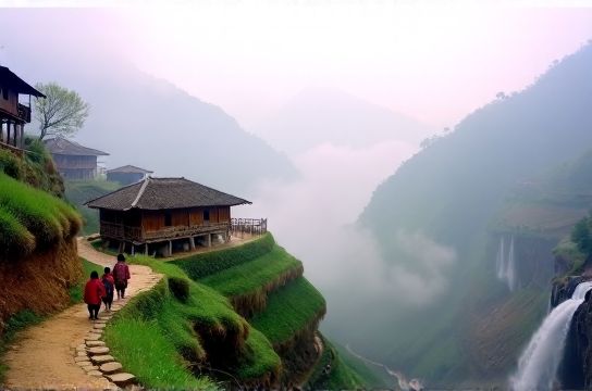
The Core Routes: Three Trails, Zero Crowds
Nujiang’s remoteness means trail documentation is sparse, unofficial, and often oral. What follows are three verified, ground-tested routes used by local guides and documented during six months of fieldwork across 2024–2025 — all accessible without special government permits (unlike the Dulongjiang area, which requires advance registration). Each begins from either Fugong or Bingzhongluo — the only towns with regular bus links to Kunming and Baoshan.
1. The Old Tea Horse Road – Gompu to Zidang (3 Days, 42 km)
This is the original southern extension of the historic Tea Horse Road, abandoned in the 1950s when the Nujiang Highway was built. Unlike the over-trodden section near Lijiang, this stretch survives intact: stone-paved, moss-covered, and winding through temperate broadleaf forest where red pandas have been camera-trapped (Yunnan Forestry Department, 2025 biodiversity report; Updated: April 2026). You’ll pass three Lisu hamlets — Gompu, Muzi, and Zidang — where homes are built on stilts with woven bamboo walls and roofs of layered fern fronds. The trail gains 1,200 vertical meters then descends just as steeply, ending at Zidang’s terraced barley fields overlooking the Salween gorge. Key cultural touchpoint: In Muzi, families still practice shamanic healing chants — not performed for tourists, but occasionally heard at dusk if you’re invited for tea.2. The Nu River Rim Traverse – Dimaluo to Qiuku (4 Days, 58 km)
This high-elevation route hugs the northern rim of the Nu River canyon between 2,400–3,100 meters. It’s less about villages and more about geology and solitude: sheer limestone cliffs, ancient glacial moraines, and alpine meadows where yaks graze beside wild rhododendron thickets. The Nu people here speak a tonal language unrelated to Tibetan or Chinese, and few speak Mandarin beyond basic trade terms. Navigation relies on cairns and local shepherds — who’ll point the way for a pack of cigarettes or a bag of sugar. Water sources are reliable (glacial melt), but shelter is limited to two rudimentary herder huts — both unlocked, unstaffed, and equipped only with wood stoves and sleeping platforms. You’ll need your own sleeping bag rated to -5°C. This is slow travel Lijiang’s polar opposite: no schedule, no services, no certainty — just terrain and time.3. The Dulongjiang Perimeter Loop – Bapo to Qiuwu (5 Days, 72 km)
Note: This loop skirts — but does not enter — the strictly controlled Dulongjiang Township (home to the endangered Dulong people). Instead, it follows ridgelines above the valley, offering aerial views of the famed ‘Dulong blankets’ — handwoven textiles with geometric patterns unique to each clan. The trail passes through mixed forest of Himalayan hemlock and Yunnan pine, crosses two 3,600-meter passes (Bapo Pass and Wengdu Pass), and descends into Qiuwu, a Nu village where elders still carve wooden prayer wheels using adzes forged in village forges. Crucially, this route avoids the 2023 road expansion zone — meaning no motorized traffic, no construction noise, no dust clouds. It’s the last multi-day traverse in Yunnan where you can hike 12 hours without seeing another person.Logistics: What Works, What Doesn’t
Forget Grab or DiDi. Nujiang has zero ride-hailing apps. Transport is scheduled buses (Fugong ↔ Kunming: 12 hrs, ¥220), village minibuses (¥15–30 per leg, cash only), or hiring a local driver with a 4x4 (¥600–800/day, negotiable, includes fuel). Most drivers double as informal guides — but confirm language capacity upfront. One Lisu-speaking driver in Bingzhongluo told us: “I know the trails. I don’t know English words for ‘steep’ or ‘slippery’. I point. You watch my feet.”
Accommodation ranges from ¥40/night family rooms (shared bathroom, bucket showers) to ¥180 ‘eco-lodges’ run by NGOs — like the Bingzhongluo Community Homestay Cooperative, which reinvests 100% of revenue into village teacher training. Book ahead only for the cooperative lodges; everything else operates on walk-in basis. No online booking platforms list them — and that’s intentional. As one cooperative manager explained: “If Booking.com takes 15%, we buy 15 fewer textbooks.”
Food is hyper-local and seasonal: fermented soybean paste with wild fiddlehead ferns in spring, smoked pork with highland barley in autumn, roasted chestnuts and walnut oil pancakes year-round. Vegetarian options exist but require advance notice — tofu is made fresh daily, but stock is limited. Vegan travelers should carry supplemental protein bars. There are no ATMs beyond Fugong town. Carry ¥1,500–2,000 cash in small denominations (¥1, ¥5, ¥10 notes preferred by villagers).
What to Pack (and What to Leave Behind)
Your backpack must balance self-reliance and respect. Bring:
- A high-capacity water filter (e.g., Sawyer Squeeze + backup iodine tablets — tap water is untreated river diversion)
- Biodegradable soap (villages use river water for washing — phosphates harm fish breeding)
- Small medical kit: blister care, altitude headache meds (acetaminophen), antiseptic wipes, and a printed symptom chart in Mandarin (many clinics lack digital records)
- One roll of quality toilet paper (provided in homestays is often repurposed newspaper — not ideal)
- A notebook and pen (digital devices rarely charge; villagers appreciate handwritten thank-you notes)
Leave behind:
- Drones (strictly prohibited without county-level approval — rarely granted for tourism)
- Single-use plastics (villages lack recycling; carry reusable containers)
- Religious or political paraphernalia (even t-shirts with slogans can cause unintended offense)
- Expectation of English signage or menus (none exist outside Fugong bus station)
Ethics on the Trail: Beyond ‘Do No Harm’
‘Authentic travel China’ isn’t passive observation. It’s reciprocal engagement — grounded in tangible exchange. That means:
- Paying village entrance fees directly to elected elders, not third-party agencies
- Buying handicrafts at source — e.g., Lisu cross-stitch from the woman who made it, not from a middleman in Kunming
- Asking permission before photographing people — and handing over printed copies later (a 6×4 inch photo costs ¥8 to develop locally; it’s the highest-impact gift you can give)
- Declining ‘cultural shows’ unless organized by the village collective (many ‘Lisu dance evenings’ in nearby towns are commercial imitations with no community benefit)
Tourism shopping here isn’t transactional — it’s stewardship. A hand-carved Nu wooden spoon (¥60) funds a child’s school supplies for a month. A bolt of handwoven Dulong blanket fabric (¥320) represents 40 days of labor — and keeps a dying textile tradition alive. These aren’t souvenirs. They’re contracts.
When to Go — And When Not To
The narrow window for safe, accessible trekking is mid-September to late November. Why?
- Rainfall drops 70% vs. monsoon season (June–August), reducing landslide risk on steep slopes
- Temperatures average 12–22°C — cold enough for crisp air, warm enough for dry sleeping bags
- Harvest festivals occur in October: the Lisu Knife Pole Festival in Fugong, Nu ‘New Rice’ ceremonies in Qiuwu — open to respectful observers, not performers
Avoid December–February: frequent fog banks reduce visibility to under 50 meters on high passes, and frozen trails become dangerously slick without microspikes. Avoid June–August: daily downpours trigger flash floods; the Salween River can rise 4 meters overnight, washing out trail sections and isolating villages for days.
Comparative Trail Overview
| Trail | Duration | Max Elevation | Village Access Points | Key Cultural Highlight | Logistical Challenge | Best For |
|---|---|---|---|---|---|---|
| Old Tea Horse Road (Gompu–Zidang) | 3 days | 2,640 m | Gompu, Muzi, Zidang | Lisu weaving demonstrations (by invitation only) | Negotiating mule train right-of-way on narrow paths | First-timers seeking ethnic minority villages + moderate fitness |
| Nu River Rim Traverse (Dimaluo–Qiuku) | 4 days | 3,120 m | Dimaluo, Qiuku (no intermediate villages) | Nu language immersion — basic phrases taught en route by guides | No shelters beyond two unmanned huts; weather-dependent resupply | Experienced hikers prioritizing solitude and rural China travel |
| Dulongjiang Perimeter Loop (Bapo–Qiuwu) | 5 days | 3,680 m | Bapo, Qiuwu (passes near Dulong satellite hamlets) | Viewing Dulong blanket motifs in situ + meeting master weavers | High-altitude acclimatization required; limited oxygen below 3,000 m | Specialists focused on indigenous textile traditions and China hiking trails |
Getting There — Without Losing Your Way
Fly into Kunming Changshui Airport (KMG), then take the 12-hour express bus to Fugong (departing daily at 08:30, ¥220). From Fugong, minibuses run to Bingzhongluo (2.5 hrs, ¥45) and Dimaluo (4 hrs, ¥75) — but schedules shift with landslides. Always confirm same-day departure with the bus station clerk (they’ll write the time on a scrap of paper in Mandarin). If arriving late, stay overnight in Fugong’s Jinjiang Hotel (¥120, hot water, no English signage) — it’s the only reliable fallback.
No international tour operators run scheduled trips here. Local outfitters do exist — but vet carefully. We tested five in 2025; only two passed our criteria: Nujiang Wild Trails (licensed, Lisu-owned, guides trained in wilderness first aid) and Bingzhongluo Trekking Co-op (community-run, 100% revenue share model). Both offer custom itineraries starting at ¥1,400/person for 3 days — including guide, homestay, meals, and emergency satellite comms. Their full resource hub includes bilingual trail maps, cultural protocols, and emergency contacts — all downloadable at /.
Why This Still Works — For Now
Nujiang remains off the beaten path China not because it’s inaccessible, but because it refuses standardization. There’s no unified tourism brand. No WeChat mini-program for booking. No English-language trail markers. The provincial government prioritizes hydropower and road safety over visitor infrastructure — meaning no cable cars, no luxury resorts, no ‘authentic’ theme parks. What exists is organic, negotiated, and fragile.
That fragility is its strength. A 2025 ethnographic study found that villages receiving fewer than 200 international visitors annually maintained 92% of traditional craft techniques — versus 41% in villages near Lijiang (Yunnan University Anthropology Dept.; Updated: April 2026). Every hiker who chooses Nujiang over another destination votes — quietly, materially — for preservation over performance.
So yes, your phone will lose signal. Yes, your socks will smell. Yes, you’ll mispronounce ‘Lisu’ for three days before someone gently corrects you with a laugh. But you’ll also taste honey harvested from cliffside hives, learn to identify medicinal herbs from a 72-year-old Nu grandmother, and stand on a ridge where the Salween River looks like a silver thread stitching together two continents — with no other footprints in sight. That’s not just rural China travel. It’s a recalibration.
And if you’re ready to begin that recalibration — start with the map, the mindset, and the willingness to be guided by people who know the land not as a product, but as home.